-
Short Version
West of England Transport Association (WETA). June 2025 (4)
DRAFT SCOPING STUDY FOR RAPID TRANSIT DEVELOPMENT IN THE WEST OF ENGLAND
‘A RE-PURPOSING OF METROWEST’
- BACKGROUND
There have been several prior ‘tram’ plans for the region, variously prepared by private enterprises, the former Avon County Council, Bristol City Council and the West of England Combined Authority. The last is on-going, but all otherwise have failed due arguably to several factors.
Earlier proposals have been insufficiently regional (so have not gained support from the entire region), have focussed on a single mode (tram or rail), have been planned separately from other potentially supportive transport policies, and have been divorced from a focus on regional development and housing plans.
This Scoping Study hopes to avoid these pitfalls. It is therefore focussed not on transport per se, but on regional development and the integration of Local Authority and private investment.
Nonetheless, to enable greater clarity, it is expressed as a development from an existing funded programme: the ‘MetroWest’ regional rail-based enhancement. In this, we blatantly imitate the campaign that successfully led to investment in and the widespread support for a South Wales Metro in our adjacent region.
- OUTLINE OF THE PROPOSED STUDY
The chosen consultancy will be asked to outline the practicalities, required physical investment, likely patronage, cost and problems of the potential investments listed below, and any others the consultants consider relevant, and a tentative priority rating of these. In particular, which pilot scheme/s and final integrated transport network/s might be the most beneficial in terms of regional housing development, regional economic investment, reduction of road congestion and attractiveness to users.
Possible routes
Existing rail corridors (see Rail Map).
Potentially low-cost highway corridors (see Road, etc. Map).
A Bristol city centre rapid transit circuit.
Potential de-motorwaying of the M32.
The former on-street tram routes of Bristol and Bath (see Road Map).
Other routes as the consultants see fit.
Technologies
Including heavy rail, tramtrains, trams or buses as appropriate per route. Including shuttles to interchange sites. Light-weight on-street trackbeds. Green-wave traffic signal technology for in-traffic highway situations, enabling tram and bus priority.
Potential public transport interchange sites
Including existing and potential Park&Ride sites (see Road Map), rail stations, suburban and other centres (Fishponds, Kingswood, Southmead Hospital, Cribbs Causeway, Hengrove Hospital, Bedminster Parade, etc.). Associated infrastructure (shelters, toilets, maps & info, etc.).
Potential rail/tram depot sites
Including existing rail sidings. Safeguarding of sites.
Complimentary planning tools
Including regional housing development policy, Workplace Parking Levy (as in Nottingham), car-commuter rat-runs management (through the Liveable Neighbourhoods programme), bus network reform (including radial, express and feeder buses). Integrated public transport ticketing.
MetroWest upgrade to rapid transit operation
Including expansion eastwards (Westbury, Frome, Trowbridge, Melksham, Chippenham), upgrade of Portishead scheme with additional stations (M5 P&R, Ashton Court, Ashton Gate), Henbury-Avonmouth loop, potential re-opening of Thornbury-Yate, Yate-Westerleigh-Emerson’s Green, Clevedon Yatton, Temple Meads-Brislington, Wapping Wharf-Ashton Gate, and Bath-Midsomer Norton lines. Safeguarding of said rail alignments.
Sources of finance
Including private partnerships, Dept. for Transport, Local Authorities’ internally-generated funds, Section 106 developers’ contributions. Potential for land-value capture.
Desirable study visits (for WECA Mayor, Councillors, MPs, LA officers, businesses)
Potentially including Cardiff, Coventry, Nottingham, Dublin, Bordeaux.
A draft programme for media involvement and public consultation
- STUDY COST
Initially, a token sum of £20,000 is to be raised to attract bids for such a study from appropriate consultancies (several of whom have already expressed interest), with the potential for generating future work controlled by public authorities.
To be partially crowd-funded, including via a media campaign. Contributions are in addition invited from those business and business organisations having a stance favourable to regional rail-based rapid transit.
- OUTPUT
Once completed, the Scoping Study will be offered to the WECA Mayor, MPs, the Local Authorities, the media and other interested parties to be taken forward.
-
Long Version
DRAFT COMMISSION FOR A REGIONAL SCOPING STUDY OF RAPID TRANSIT OPTIONS FOR BRISTOL, BATH AND THEIR REGION
Prepared for West of England Transport Association (WETA). Jun 2025. (14)
EXECUTIVE SUMMARY
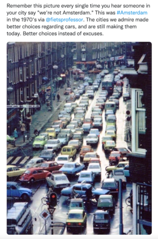
Bristol is one of the largest cities in Britain or Europe without a rapid transit system. As a result it suffers from congestion, pollution and a certain amount of economic inefficiency. Previous plans for a return of trams to the city have failed partly due to an insufficiently regional perspective (which alone will reduce the number of cars entering the city), lack of an integrated multi-modal perspective, and a lack of public buy-in. A new alliance of interested persons – WETA, the West of England Transport Association – propose to crowd-fund a Scoping Study for Rapid Transit in the West, similar to that which has successfully resulted in an integrated rail and tram network for Cardiff, Newport and the Valleys now under construction. The aim is to increase economic and travel efficiency, and to structure future housing planning. The Study will be funded to £20,000: a token sum to interest a rapid transit engineering consultancy. Particularly to be assessed are the practicalities, costs, benefits and impacts of:
* reopening the rail lines to Thornbury, Clevedon, Severnside and Westerleigh (alongside those to Portishead, Brislington and Wapping Wharf already under consideration),
* introducing rapid transit to the M32 (de-motorwayed), Avon Ring Road, Temple Way and other wide highways,
* expanding (and integrating with rapid transit) the rings of park&ride sites around Bristol and Bath, and
* essential parallel initiatives including Workplace Parking Levies, rat-run suppression, integrated public transport ticketing and a restructuring of connecting bus services (including orbital and feeder routes).
Once completed, the Study will be submitted to WECA as Regional Transport Authority to take on as they wish. Soundings will be taken in the interim of Local Authorities, MPs, business organisations and the media, as was done in South Wales.
- INTRODUCTION: PREVIOUS STUDIES
There have been several previous studies. Yet none:
- have a regional perspective (equivalent to that of the Welsh Government study for Cardiff, Newport and the Valleys),
- replicate the Welsh study’s full evaluation of existing regional transport infrastructure,
- are neutral with respect to mode (whether rail, tram, bus rapid transit or bus),
- focus on the need for housing development location to be transport facility led,
- have been the subject of widespread public information and debate.
In approximate date order, these partial studies are:
- Advanced Transport for Avon, 1987 (see for example http://claphammodelrail.com/fancyapps-fancyBox-18d1712/demo/The Avon LRT Bill 1.pdf ).
- Avon County Council, then Bristol City Council/South Gloucestershire Supertram proposals, 2004 (see Wikipedia>Bristol Supertram).
- WECA’s MetroWest rail plan (available at: http://westofengland-ca.gov.uk/what-we-do/transport/metrowest; Wikipedia>MetroWest (Bristol) ).
- Bristol & Bath Area Tram Association studies of trams for Bath (see bathtrams.uk/ solving-baths-traffic/one-set-of-proposals-for-a-new-tram-layout).
- Transport for Greater Bristol/Zero West – Bristol on-street tram study (available at: tfgb.org>campaigns> Moving Bristol Forward>detailed study).
- Bristol City Council Mass Transit studies, 2023 (web search: Bristol City Council mass transit).
- West of England Combined Authority Cttee, 2024, Outline Business Case, WEST Rapid Transit.
Each give useful insights, yet are insufficient for purpose.
- AN OUTLINE REGIONAL SCOPING STUDY OF RAPID TRANSIT FOR BRISTOL, BATH AND REGION
INTRODUCTION. QUANTITATIVE MODELLING, OR REGIONAL NETWORK VISION?
Transport planning in Britain has relied heavily on ‘transport models’ (see Appendix 1) – a very expensive form of mechanical trend planning, in which large transport consultancies have cornered the market. This is far less so on the Continent, where planning combines parallel land-use development planning, and transport investment decision-making, and is more vision-led. (Modelling there focusses on engineering detail, as in micro-modelling for junction capacity design). Fortunately, vision-led integrated land-use/transportation planning is now much more the case in British locally-controlled metro city planning, as recently seen for both West Yorkshire and South Wales (Cardiff, Newport and the Valleys).
Rather than assume transport investment should follow ‘demand modelling’, metro, Continental and Welsh policy is that investment and service provision can create demand. Such an approach was amply justified by London Mayor Ken Livingstone’s policies of Fares Fair (lowered public transport fares) and the London Overground (orbital rail services) in the 1980s.
THE SCOPING STUDY – AIMS AND OBJECTIVES
We take the view that the West, in order to continue to prosper economically and to cater for planned housing growth, requires a modern regional and urban rapid transit (‘metro’) network comparable to those planned for West Yorkshire and South Wales, as well as in progress for the West Midlands, Nottingham, Sheffield, Croydon, London Docklands, Greater Manchester, Tyneside, Coventry, Edinburgh, Dublin, and is standard world-wide.
In the continued absence of a rapid transit metro network, the West inevitably will remain car-dominated and car-dependent – with all the concomitant problems of inefficiency, inequality, congestion and pollution.
A low-investment solution – such as one relying on buses or bicycles – is no solution; nor regarded as such by other metro areas. We need a rapid transit plan ready, consulted upon and agreed, to be enacted upon as soon as initiating funding becomes available.
The most recent example of such a plan is that of Cardiff, Newport and the Valleys, which, as we intend for the West, was first mooted by not the official planning authorities but by community, academic and business interests. We intend to replicate that situation here in the West, and for that purpose outline in this document a scoping study to be carried out by a competent engineering consultancy and thereafter advocated to all regional political bodies, the media and the public, in order to create a groundswell of opinion sufficient for it to come to pass. As happened in South Wales.
A major consideration is that a rapid transit plan should be instrumental in decisions as to where new housing should be built in the region. The government has set Local Authority housing targets. Accessible housing development and transport planning must proceed in parallel.
The study should include the following elements.
AN EVALUATION OF EXISTING REGIONAL TRANSPORT INFRASTRUCTURE
Existing rail-based infrastructure
- Mainline rail
To London, Birmingham, Cardiff, Taunton, Salisbury and via Bristol Parkway.
- Agreed MetroWest lines
To Severn Beach, Avonmouth/Henbury, Portishead. But with additional rapid transit stations.
- Potential rail re-openings
Thornbury-Yate,
Clevedon-Yatton,
(Whitchurch)-Brislington-(Temple Meads)
Yate-Westerleigh-Mangotsfield-Fishponds-(Temple Meads),
Wapping Wharf line (Ashton Gate-Harbouside),
Radstock-Bath.
Map 1 – A Expanded MetroWest Rail network
Existing lines, planned lines, other options.
Existing road-based infrastructure
- National motorway network: M4, M5,
- M32
- Avon Ring Road
- Other wide highways suited to relative ease of rapid transit inclusion:
- In Bristol: Easton Way/St Philips Causeway, Bond St/Temple Way, Clarence Rd/Commercial Rd, Redcliffe Way, Redcliffe Hill/Bedminster Parade, Malago Rd, Callington Rd/Airport Way/Hengrove Way/Colliters Way, Whitchurch Lane (part), Hartcliffe Way, Winterstoke Rd, Brunel Way/Ashton Rd, Portway, Falcondale Rd, Passage Rd/Cribbs Causeway, Hayes Way, Highwood Rd, Gloucester Rd North, Park Ave, Bradley Stoke Way, Gypsy Patch Lane/ Winterbourne Rd/Great Stoke Way/Stoke Gifford Bypass, Bromley Heath Rd.
- Keynsham Bypass/Bath Rd (part – to Brislington P&R).
- Long Ashton Bypass
- Former on-street tram routes (more expensive):
- Bristol: city centre circuit.* Gloucester Rd, Fishponds Rd, Lawrence Hill, Bath Rd, Wells Rd, Bedminster Parade, Hotwell Rd, Whiteladies Rd.
- Bath: city centre circuit, London Rd, Upper Bristol Rd, Lower Bristol Rd, Wellsway.
Map 2 – Highway network suitable for rapid transit.
PARALLEL TRANSPORT PLANNING CONSIDERATIONS
Integrated public transport ticketing
Form, and organising body.
Potential additional Park&Ride schemes at:
- Motorway exits M4 (J10, J19); M5 (J15, J16, J17, J18, J19).
- Outer termini of ‘former on-street tram routes’ (above).
- Rail/motorway crossing sites (at new or existing motorway junctions).
Interchange hubs
Phase 1: Bus/bus; bus/rail if at station. Phase 2 upgrade to rapid transit interchanges where appropriate.
In Bristol: Temple Meads, Bristol Centre, Haymarket, Cabot Circus, Old Market, Filton, Aztec West, Cribbs Causeway, Bristol Parkway, Southmead Hospital, Emerson’s Green, Fishponds, Staple Hill, Kingswood, Redfield, Longwell Green, Brislington P&R, Arno’s Vale, Broadwalk Knowle, Hengrove Park, Bristol Airport, Imperial Park, Bedminster Parade, Ashton Gate, Avonmouth, Severnside.
Workplace Parking Levies
à la Nottingham
City centre vehicular access schemes
Bristol. (Bath exists).
Closure of car-commuter rat-runs
Bristol City Council’s Liveable Neighbourhoods schemes.
Bath.
Completion of Residents Only Parking Zone rings
Bristol.
Bath.
Highway heavy goods routes and their requirements
Break-of-bulk depots, vehicle access routings.
Republish the Commercial Vehicles Driver’s Atlas (Bristol City Council/Bristol and Neighbouring Authorities Freight Quality Partnership, 2003). Upgrade to satnav version.
AN ANALYSIS OF RAPID TRANSIT OPTIONS
Integration of rapid transit with rail, bus, car and cycle
Ticketing, interchange hubs, complementary routes, Park&Ride, cycle parking and cycleways.
Route options
Rail corridors, rail/highway rapid transit route options, bus corridors, orbital routes.
Vehicle types and route capacities
Consider heavy rail, tram-train, tram, bus, bus rapid transit.
Depot sites
Note existing rail depot sites at: East Depot Whitby Rd, St Philips (several), Totterdown, Bedminster Down, South Liberty Lane, Filton Triangle. Safeguarding thereof.
Possible site options at out-of-town rapid transit termini.
Route safeguarding
Which alignments and sites require safeguarding? By which Authority and by which device?
Compulsory purchase
Consider which sites have land as an issue (safeguarded alignments, required route realignments, station sites, depot sites, P&R sites).
Approximate costs per line
Including land acquisition, track costs, signalling, bridges etc., rolling-stock, depot, stations/stops.
Approximate benefits per line
Anticipated demand, route capacity and predicted usage.
RECOMMENDATIONS
Selected schemes for further study
Recommended rapid transit network, specific lines. See Appendix 2.
Phase 1: heavy rail and bus options
Phase 2: partial conversion to rapid transit
Optional pilot route.
CONSIDER BEST TO MAKE PROGRESS
Who needs to be brought onboard at an early stage?
WECA, Local Authorities, MPs, town campaigns in Portishead, Clevedon, Thornbury, etc., Civic Societies, individual LA officers, local media, business organisations, universities, transport campaigns, major local businesses, Port of Bristol, YTL (Filton Airport), Network Rail officers, DfT, Labour Ministers, possible civil engineering consultancies, possible rolling-stock manufacturers, grant-giving bodies for the study.
Media campaign
Public meetings
Political assent
No vision or plan is likely to succeed unless it has general buy-in. It needs to secure cross-party agreement.
Incremental and realistic
Due to financial constraints, implementation can only be incremental. An early relatively low-cost success is required, in order to establish public confidence, political support and to increase the likelihood of further government and private investment. Flashy expensive vanity white elephants Bristol has seen before, and is unimpressed by; they are dysfunctional and time-wasting. As illustrative only, initial schemes might for example be any or some of:
- a South Bristol-Severnside bus,
- safeguarding, through the planning system, rail alignments and rail depots,
- de-motorwaying the M32 (and eventually removal of grade-separated structures, to create at-grade working).
- an Avon Ring Road bus, Keynsham-Emerson’s Green-Bristol Parkway-Cribbs Causeway-Severnside,
- an integrated rail/(future tram)/bus WEST ticketing scheme (like London),
- compulsory purchase of future Park&Ride sites,
- an upgraded Henbury-Temple Meads rail service,
- upgraded West Wilts rail network service levels,
- an M4 Park&Ride bus, via the M32 to Bristol Centre,
- a reopening of the Henbury rail Loop,
- a Bristol Workplace Parking Levy.
To give due credit, most of the above can be regarded a continuation of existing progress with the WECA MetroBus and MetroWest programmes.
So far however, no regional integrated rail/tram/bus rapid transit plan has been formulated or agreed. Therefore at the same initial stage, work should begin designing and initiating a pilot tram scheme. This might be, for instance:
- trains operating on the Henbury and West Wilts rail lines,
- a rail line re-opening,
- a Bristol city centre tram circuit,
- (after the current Portishead tail scheme has been implemented), a phase 2 Portishead scheme: as rapid transit, with additional stations at Ashton Court, Ashton Gate and with a Park&Ride at M5 junction 19. (A phased eventuality occurred for instance with London’s Docklands Light Rail).
- a more complex mixed rail/highway tram scheme, perhaps:
- Thornbury line-Yate-Westerleigh line-Emerson’s Green-Avon Ring Road-M32-Bristol Centre, or
- Temple Meads-Brislington line-A4-thence Bath and/or South Bristol-Hengrove Way-Bristol Airport.
A West of England regional rapid transit metro would be an incremental 25 year project, gaining annual government grant inputs, local financial contributions (through a Workplace Park Levy for instance, or land value capture schemes) and private investment. A metro system for Bristol, Bath and region needs to be prepared to catch the government’s windfall of pension funds investment; we must not miss our chance yet again.
APPENDIX 1: QUANTITATIVE DEMAND EVALUATION
Outline the analysis required.
Demand modelling should include the following:
A map and scaling of the main population (‘origin’) centres
Bristol, Bath, Swindon, Corsham, Keynsham, Warminster, Westbury, Trowbridge, Bradford on Avon, Melksham, Chippenham, Frome, Midsomer Norton/Radstock, Shepton Mallet, Wells, Cheddar, Weston super Mare, Bridgewater, Taunton, Burnham, Yatton, Clevedon, Nailsea, Thornbury, Yate/Sodbury, Winterbourne/Coalpit Heath, Stroud, Chepstow, Newport, Cardiff, Gloucester, Cheltenham.
A map and scaling of the main ‘destinations’
City centres, suburban centres, out-of-town retail centres, employment centre, universities, hospitals, sports/entertainment facilities, transport hubs.
Within Bristol area: city centre, Filton, Aztec West, Cribbs Causeway, Bristol Parkway, Southmead Hospital, Emerson’s Green, Fishponds, Staple Hill, Kingswood, Redfield, Longwell Green, Brislington, Broadwalk Knowle, Hengrove Park, Bristol Airport, Imperial Park, Bedminster Parade, Ashton Gate, Avonmouth/Severnside.
APPENDIX 2. SPECIFIC ASSESSMENTS OF PREVIOUSLY SUGGESTED SCHEMES
Any scoping study should ensure that at least the following previously suggested pilot schemes are evaluated for practicality and value-for-money.
Rail up-grades
- An up-grade of MetroWest to rapid transit. Include services to Melksham, Trowbridge, Westbury, Warminster, Frome.
Rail re-openings
- Portishead-Temple Meads. (Agreed, but perpetually delayed, perhaps due to its limited ambition). Prepare a phase 2 scheme: a rapid transit service, additional stations at M5 J19 P&R, Ashton Court, Ashton Gate. Requires negotiation with Port of Bristol re shared freight usage.
- Henbury-Temple Meads. (Funded and in progress). Prepare a phase 2 scheme: a rapid transit service, complete the ‘Henbury Loop’ connection to Avonmouth, additional stations at Chittening, Hallen. Add a service direct to Bristol Parkway. Add a link into Cribbs Causeway. Requires negotiation with Port of Bristol re shared freight usage.
- Clevedon-Yatton. A shuttle rapid transit service, or heavy rail through to Temple Meads. Requires M5 bridge, route realignment in Yatton, line safeguarding.
- Thornbury-Yate. A shuttle rapid transit service, or rapid transit through to Bristol Centre (via Yate-Emerson’s Green rail alignment, Avon Ring Road and M32 – see below). Stops at Grovesend Rd Thornbury, Tytherington M5/A38 P&R, Iron Acton, alterations to Yate. Requires possible new bridges at A38 and M5. Line safeguarding.
- Radstock- (No details available).
- Yate-Westerleigh-Emerson’s Green-Staple Hill-Fishponds-(Temple Meads). Could be reopened in part or whole, as rapid transit. Requires negotiation with existing oil depot rail user. Negotiation with cycling interests re parallel usage (as on Warmley-Saltford line). Enables a Yate-Bristol rapid transit service while avoiding Westerleigh viaduct mainline congestion point. New stations at Westerleigh, Emerson’s Green. If continued to Temple Mead, requires bridge at Avon Ring Road.
- Whitchurch-Temple Meads. (Variously planned as a highway or as rail re-opening for bus or rapid transit). Re-opening could be partial, to Brislington (either A4, or Callington Rd) or to Whitchurch. Whitchurch A37 P&R. Negotiation with cycling interests re parallel usage. Links into Bristol-Bath routes, and South Bristol orbital (see below, 14).
- Wapping Wharf line (Harbourside-Ashton Gate). Owned by BCC. Formerly used for Harbour (Steam) Railway. New Cut (Ashton Ave) Bridge currently used by ‘guided bus’ Long Ashton P&R MetroBus service. Formerly proposed as a rapid transit route between Bristol Centre-Spike Island-Cumberland Basin-Long Ashton potential housing development area. Requires engineering evaluation of Ashton Ave. Bridge.
Highway repurposings
- M32. Both BCC and Highways England policy is to de-motorway, due to environmental and network considerations, and the cost liability of its existing grade-separated structures.
Prepare a phase 1 scheme: M4/Avon Ring Road P&R, bus-lanes, bus service to Bristol Centre.
Prepare a phase 2 scheme: demolition to surface level, rapid transit lane(s), continued usage of rest as a lorry and general distributor traffic route, bus/RT stops at junctions, pedestrian crossings.
- Bristol City Centre Circuit. Temple Meads-Temple Gate-Bond St-Haymarket-Lewin’s Mead-Centre-Baldwin St-Bristol Bridge-Victoria St (or Centre-Prince St-The Grove-Redcliffe Way-Temple Meads).
Existing P&R bus services circuit.
Prepare a phase 2 scheme: upgrade to rapid transit. Links into M32 routes and all former Bristol on-street tram routes (see 13, below). Interchange with Temple Meads rail at Friary. Requires engineering evaluation of Bristol and Redcliffe Bridges.
- Portway (Hotwells-Avonmouth). Existing partial bus-lanes for P&R bus service. Prepare a phase 2 scheme: rapid transit, linking Bristol Centre to Severnside. Hotwells and Avonmouth interchanges.
- Avon Ring Road. Keynsham-Filton-(continue to Cribbs Causeway-Severnside). Bus/RT lanes, traffic signals, bus/RT stops, pedestrian crossings, several P&R site options.
- Other orbital routes. Orbital bus services. Possible phase 2 rapid transit
- Easton Way/St Philips Causeway. Stops at junctions and Avon Meads, can continue to A38 via (Lower) Ashley Rd.
- South Bristol orbital 1: (Brislington P&R-West Town Lane-) Callington Rd-Airport Way-Imperial Park-Hengrove Way-Colliters Way-Long Ashton P&R. Links through to Brunel Way-Portway-Severnside. Could branch to Bristol Airport via A38.
- South Bristol orbital 2: Hengrove Park-Imperial Park-Hartcliffe Way-Winterbourne Rd-(linking to Long Ashton P&T and/or Hotwells).
- Brunel Way. Replacement bridge needs to be tram-compatible. A possible component of South Bristol orbital extended to Severnside via Portway, and of Bristol-Bristol Airport route via Bristol Centre-Hotwell Rd-A370-Colliters Way-A38.
On-street tram options
(More expensive).
- Bristol city centre on-street tram circuit.
* (Several options have been suggested. A tramtrain connection from Temple Meads is not advised, as vehicle costs are higher, a heavier trackbed is required and high-floor platforms are not ideal. A Bond St-Temple Way routing is preferable (to Horsefair-Penn St) in order to integrate with potential on-street routes from Gloucester Rd and M32).
- Bristol radials: see above (‘former on-street tram routes’).
- Bath radials: see above (‘former on-street tram routes’).
Mixed rail/highway rapid transit schemes
- Bristol-Bath. Temple Meads-Whitchurch rail re-opening-A4 Bath Rd on-street-Bath. And/or linking into South Bristol orbital 1 (see 14, above), This scheme is a component of several former and on-going studies. Could be bus, bus rapid transit or tram. Could be extended to Bristol Airport via A38.
- Thornbury-Yate-Bristol Centre. Thornbury-rail reopening-Yate-Westerleigh line reopening-Emerson’s Green-Avon Ring Road-M32-Bristol Centre. (See above, 5, 7, 13, 10, 11).
Prepared for WETA by Gavin Smith (Bristol City Council, Transport Planning & Public Transport teams, retired). Version 11, Feb 2025.